
This story initially appeared in the ACOR Newsletter, Summer 2014, Volume 26.1. To read the entire newsletter, or any of ACOR’s previous newsletters, please visit the ACOR website.
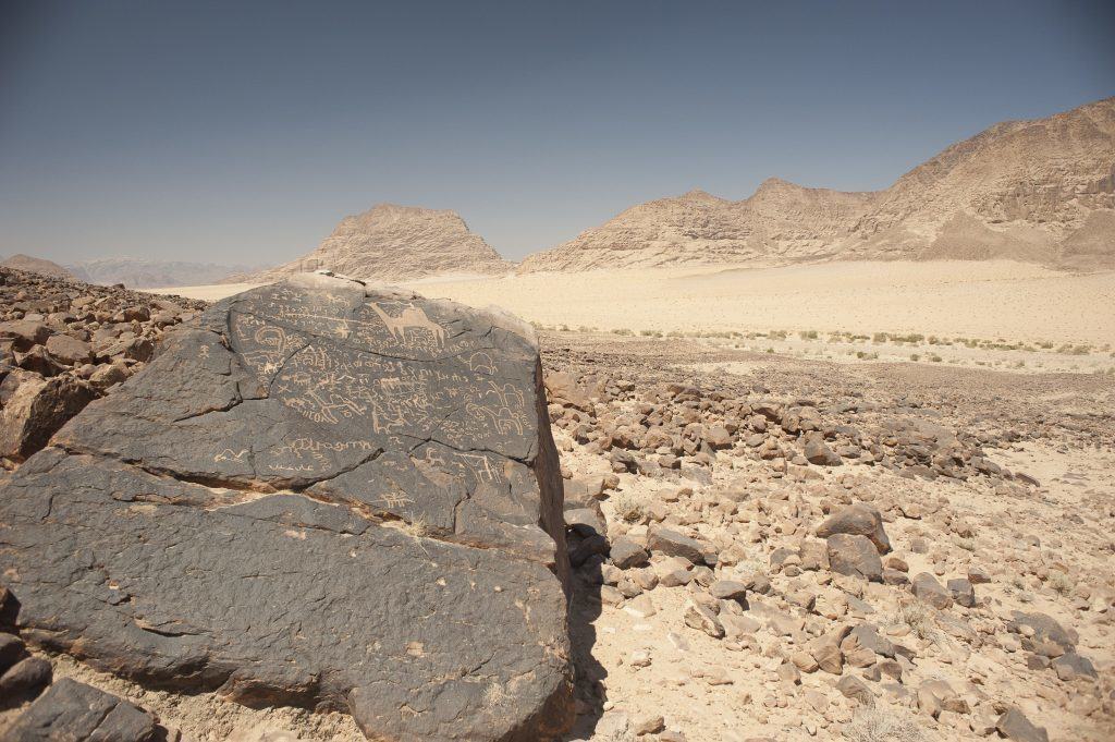
Wandering through the breathtaking scenery of the Hisma desert in southern Jordan—the region popularly known as Wadi Ramm—one often stumbles across the inscribed messages of the ancient peoples who inhabited this remote corner of North Arabia some two thousand years ago. Carved on the innumerable boulders and rock faces of this towering, wind-swept landscape, these inscriptions—termed “Thamudic E”or“Hismaic” by scholars—are striking reminders that human culture can survive and thrive in even the remotest settings.
Used and written primarily in what is today southern Jordan and northwestern Saudi Arabia, Hismaic is part of a family of dialects and scripts known to scholars as Ancient North Arabian. Linguistically similar to Arabic, Ancient North Arabian was written in various but closely related forms of the alphabetic script indigenous to ancient Arabia beginning sometime in the first millennium B.C. Based on clues found in the inscriptions, Hismaic seems to have been used by the tribes of the Hisma in the centuries around the turn of the era, when the Nabataean kings of Petra held economic and political sway over much of North Arabia. Several thousand such inscriptions have now been recorded, almost all of which are the simple, personal messages of local nomads and pastoralists who, in addition to leaving their names and the names of their fathers and forefathers, wrote short prayers to Nabataean and Arabian gods, mused about lost loves and departed friends, and autographed often exceptional drawings of desert life and activities, particularly scenes of camels and hunting.

Since 2005, I have directed the Wadi Hafir Petrogylph Survey, which aims to use the methods of modern survey and landscape archaeology to gain greater insight into these mysterious messages and the lives of those who left them. The Wadi Hafir is a long, narrow canyon located in the northern Hisma (about 15 km north of Diseh village) that gradually rises from the desert’s soft dune sands to the rugged heights of the Rasen-Naqab escarpment and the Ma‘an plateau. With slopes and wadis littered with endless fields of blackened sandstone boulders, the Hafir preserves thousands of Hismaic inscriptions and drawings, not to mention countless other examples of rock carvings dating from the Neolithic to the present. The Hafir was first surveyed in the 1980s by the late Australian scholar and former ACOR Annual Professor William Jobling as part of the ‘Aqaba-Ma‘an Archaeological and Epigraphic Survey (see ACOR Newsletter No. 1 [November1989], pp. 4–5). With permission from Jobling’s family to use the archive and photo records of his earlier survey, the WHPS has been, in many ways, an attempt to update, analyze, and ultimately publish the findings from Jobling’s important work. Using high-powered digital cameras, handheld GPS units, and a systematic surveying strategy, the WHPS has now recorded the precise locations of many of the inscribed stones photographed by Jobling as well as hundreds of others.
The GPS points, along with relevant information about each inscription and drawing, have also been input into a Geographical Information System (GIS) that allows site locations to be viewed over high-resolution satellite images, detailed topographic maps, and hydrological data. The resulting GIS database has proven a powerful tool not only for querying the content of the carvings, but also for analyzing and interpreting meaningful patterns within their spatial distribution. For example, locations where inscriptions tend to concentrate were mapped in relation to local rainwater runoff patterns. Though the carvings were certainly found scattered throughout the research area, close analysis shows that they often cluster in deep wadi interiors, at precisely those spots where runoff from powerful winter rains tends to drain, collect, and pool. This distribution shows that the authors of the inscriptions, much like their Nabataean contemporaries, were keenly aware of desert topography and hydrology and knew exactly where to go to find both water and pasture for their herds as well as the watering holes of the ibex, oryx, and ostrich they so frequently hunted. What is more, analyzing the content of the carvings within a GIS allows us to track the movements of individual authors, many of whom signed their names multiple times, and even discern other family members and friends who may have joined them on their travels through the wadi.
Another aspect of my research seeks to understand the various meanings the authors of the texts may have ascribed to their carved words and images. All too often these texts have been treated as little more than idle graffiti, spontaneous creations of the moment that offer only passive reflections on the lives and thoughts of those who carved them. But by studying the texts in light of archaeological, historical, literary, and poetic evidence from Nabataea and ancient Arabia, it is clear that many of these carvings were, in fact, meaningful creations that convey something of the authors’ thoughts, ideas, and experiences. In pre-Islamic Arabia, as in much of the rest of the ancient world, for example, written words were repositories of power, physical vessels that gave material reality to prayers, curses, and the eternal desire for one’s name and lineage to be remembered. Similarly, camels and hunted animals, which appear so often in the signed drawings of the Hisma, were images laden with potent symbolism related to death and the sacred. Camels, for example, in addition to being esteemed sacrifices offered to Arabian gods, were often buried with their owners to serve as mounts in the afterlife. Likewise, hunted animals like the ibex and the oryx had strong ritual associations; both were considered sacred to major deities and may also have been venerated as fellow sentient beings by the desert tribesmen who still partially depended on hunting for their subsistence.

My ongoing research in the Wadi Hafir has also allowed me to collaborate with George Bevan, professor of Classics at Queen’s University in Ontario, to establish new, state-of-the-art digital photographic methods for recording North Arabian inscriptions and carvings. These methods can produce dynamic three-dimensional representations of carved surfaces, informative re-lighting and enhancement of worn carvings, and super high-resolution images of carved stones and landscapes. Using a technique called digital photogrammetry, for example, we are able to convert scores of high-resolution images of the same stone into an incredibly lifelike 3D model that can then be viewed, manipulated, and analyzed with computer software. By using an array of digital filtering, shading, and re-lighting tools, the user can enhance or reveal details on an object’s surface that are difficult or impossible to see in standard digital photographs or even with the naked eye. Given the inherent problems of weathering, ancient vandalism, and heavy patination found among North Arabian carvings, where important details are often faint, obscured, or obliterated, photogrammetric imaging thus opens up valuable new horizons for analyzing and interpreting these remains.
In the coming years, the WHPS will continue using the latest methods and technologies to locate and redocument as many of Jobling’s sites as possible, while also working to digitize and catalogue all of the original photographs, notes, and readings contained in his survey archive. Ultimately, the results of both surveys will be published in a single comprehensive volume documenting the impressive archaeological, epigraphic, and rock art remains of the Wadi Hafir. At the same time, the GIS database of Hismaic carving locations and content will be expanded to include Jobling’s work, thereby providing scholars a robust and powerful tool for discerning the names, movements, and activities of the individuals and families who roamed the valley nearly two thousand years ago.
Written by Glenn Corbett